
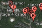
Local activists who are calling for a swift and full cleanup of the area have produced a map showing over 70 cases of cancer or illness around the contaminated CTS of Asheville site (follow the link to the map, above, then scroll to the bottom of the page it takes you to). They assert that this is linked to toxins in the area, especially trichloroethylene, a suspected carcinogen.
Wells in the area have been found to be contaminated with TCE. The map was sent to Xpress by Tate McQueen, a resident of the Mills Gap Road area that’s been affected by the contamination.
A large version of the map was displayed at a recent Buncombe County Board of Commissioners meeting, as McQueen, serving as spokesperson for residents of the area, blasted federal, state and local agencies’ handling of the cleanup.
An Xpress-requested 2008 analysis by the North Carolina Central Cancer Registry covering a 1-mile radius around the site found no increased rate of cancer, but was, by the admission of health officials, “very limited.”
— David Forbes, staff writer