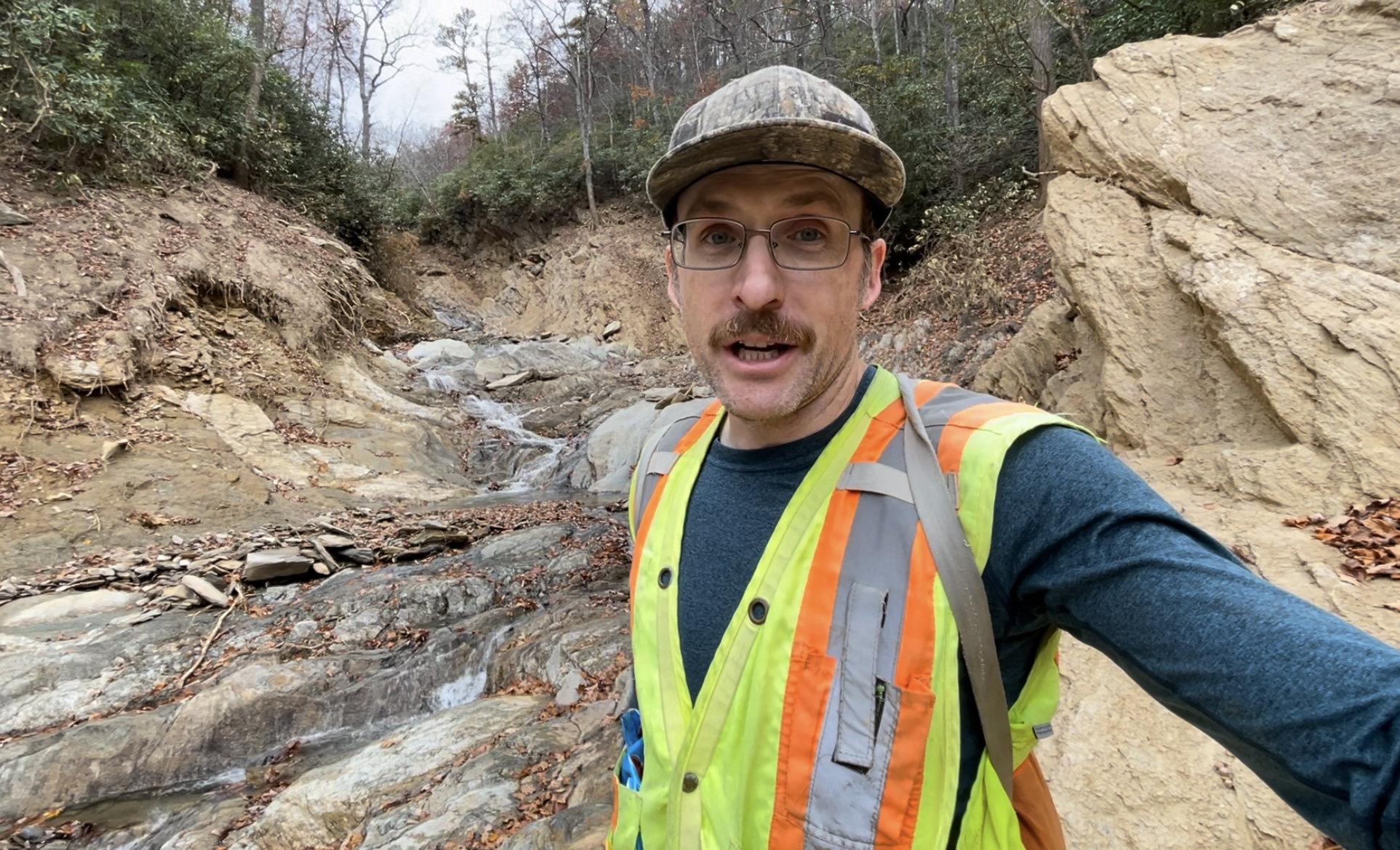
It’s not often that a geologist becomes the most famous guy on YouTube, but in the weeks following Tropical Storm Helene, you couldn’t stand in a drinking water supply line around Asheville without someone raving about “the geomodels guy.”
People were desperately trying to understand what had just happened to turn their mountain refuge into an unrecognizable hellscape. Geologist and landslide researcher Phillip Prince thought he might be able to help.
After the storm, the Greenville, S.C.-based geologist was in the Fairview area assessing how landslides affected roads during the storm. He kept hearing people talk about the devastation from debris flows in Craigtown and Garren Creek, trying to get their heads around what happened.
So he made a 28-minute video explaining the science behind how mountainsides wound up in their backyards.
“I made that first video [after] talking to people in that area. People had questions based on their experience with it, and their efforts to try to understand what on Earth had just happened,” he says.
It turns out more than just neighbors in Fairview were interested. The video, posted Oct. 11, blew up, garnering about 30,000 views per hour by that evening, a pace of interest that Prince had never seen his videos garner before. Eventually, almost 500,000 people would see that first video. He went on to make about a dozen about Helene, focused on areas most affected by the storm, from Chimney Rock to the Nolichucky Gorge.
Originally from Greenville, Prince got his undergraduate degree from Furman University. He thru-hiked the Appalachian Trail before living in Virginia for years, eventually getting his Ph.D. at Virginia Tech University in geomorphology, with research focused on the Appalachian mountains.
In 2019, Prince moved back to Greenville to live near his parents and started working at Asheville-based firm Appalachian Landslide Consultants. He still serves as an adjunct professor at Virginia Tech, where he started making videos for his students 11 years ago. He didn’t start making public videos on global geology and posting on the GeoModels page until 2023, he says.
“I’m interested in how material moves at large scale in the Earth, so that might be big landslides, or how mountain ranges are built, or how tectonic plates can interact in different ways and produce different geologic structures and different landforms,” he says.
He also studies what types of videos get interest and attempts to keep viewers engaged while still explaining complex science.
“The deeper you get into the geology, the fewer people are going to see your video. To max out your YouTube performance, you have to be careful about how much you’re asking of the viewer, who is probably just trying to unwind after a day of work,” he notes.
His videos on Helene bounce back and forth between Google Earth and Microsoft Paint, sometimes mixing in on-site photography to illustrate his explanations.
“People seem to want to engage with stuff that looks cool more than stuff that doesn’t look cool. So I guess I try to find things that I think look cool,” he says.
Prince sat down with Xpress six months after the storm to reflect on his brief local fame, why he made the videos and what geologic legacy the largest natural disaster in his lifetime — so far, at least — will leave.
Xpress: What were you up to as Helene approached?
Prince: I had been working in Virginia right up to the night before. I decided I was going to drive back [to Greenville] Thursday night just so I didn’t have to drive back in the weather the next day. The anticipation of the scale of the event was just not there.
[Appalachian Landslide Consultants] had been doing a landslide inventory in McDowell County, and we’d been working on it for a couple years. At that point, the state was funding — and continues to fund — landslide mapping within mountain counties for the purpose of understanding where slides happen and what kind of soil conditions favor them, how far they’re going to go downhill, etc. We were trying to say what a worst-case scenario would look like in Western North Carolina from a landslide standpoint.
How does Helene compare to previous disasters like 1916?
Helene was unquestionably worse than 1916, and, depending on where you go, probably substantially worse. My sense is that the scale of this event really was above and beyond.
In terms of how slopes behaved, where the landslides, and particularly the debris flows, or mudslides, occurred, how they started and how far they traveled … it’s consistent with information we’ve collected and reported back to the state.
In some places like the Craigtown debris flows in Fairview, where there is massive impact a huge distance from the foot of a mountain, that is not something that has really been observed or recorded before, and that type of behavior is something that’s going to receive a lot of attention to increase awareness going forward.
What surprised you most about Helene’s landslides?
It’s not so surprising that there were such a large number of slides from Helene. If it rains that much, you’re going to have a lot of landslides. No question there. I think how far some of them traveled [was surprising]. These big debris flow landslides, as they move downhill, sort of fluidize and almost flow like liquid with soil and rock. They went a really long way. They move fast, their potential for impact, and how they just kind of gut the little stream channel that they end up following down the mountain. I’ve seen it before, but some of the big ones with this event were really just exceptional. Just the scale, the amount of wood that they move, the amount of trees that come down the mountain with one … I guess you anticipate that, but the reality of it was striking to see. The amount of damage that a large and highly mobile landslide will do is quite staggering.
Another surprise is there were places that had really steep terrains that had just as much rainfall as the other side of the ridge, but their geology was a little bit different, and the landslides that happened there did not travel quite as far, and ended up being not as deadly as slides in other places. That’s something that I think needs to be further studied.
Why is it important to record all these landslides?
It’s so people can look back at it and see what happened. There are probably a dozen landslides that we know for a fact are from 1916. We don’t know exactly how far they went. We don’t know what their impacts were. It was the benchmark event, but we have almost no record of what that actually looked like. As Helene approached, the National Weather Service said this is going to be the biggest storm of the modern era. But how bad is the biggest storm of the modern era actually going to be? There wasn’t a way to visualize just how significant that was. So we’re trying to keep a record of what happened and determine what made them behave like they did so that next time people are not going to wonder what it’s going to look like.
How should we prepare for an event like Helene going forward?
First and foremost, we need acceptance and awareness. A common thing I’ve heard from people is, “I moved here to get away from the storms,” or “Hurricanes don’t come to the mountains,” or “These mountains are supposed to be safe and protect you from bad stuff from the outside.” That can be the case in some scenarios, but this kind of thing happens here. It happened in 1916. It’s happened throughout time. And I think there needs to be an acceptance that now and then, you’re going to see events like this. You have to understand that they’re going to produce a lot of flooding and that there’s going to be this debris flow type of landsliding, where you have really fast, destructive slides that are going to come roaring down the hill and kind of blast out into the valley below. And if you’re in their way, you know it’s going to be bad for you.
It doesn’t mean you shouldn’t live in the mountains. It just means you need to be aware of what can happen and when those conditions are right, you need to take action.